Laste ned presentasjonen
Presentasjon lastes. Vennligst vent

1
Objektiv farvannsinformasjon Pålitelige prognoser Trygg sjøtransport Eksempler fra Hellas og Spania Svein Erling Hansen Oceanor ASA

2
Sikring av farledene KartKart –Nye oppmålinger –Digitale kartsystemer Merking av farledeneMerking av farledene Overvåking av farledene, trafikkontrollOvervåking av farledene, trafikkontroll Meteorologisk varslingMeteorologisk varsling Sann-tids overvåking av vind, strøm og bølgerSann-tids overvåking av vind, strøm og bølger

3
Sleipner ulykken " Sleipner" bare godkjent for en meters signifikant bølgehøyde "Sleipner" hadde bare driftstillatelse til å seile i opptil en meters signifikant-bølgehøyde, fordi tester av rømningsveier og redningsutstyr ikke var gjort i grov sjø. Ulykkeskvelden var bølgehøyden to-tre meter. (sitat granskningsrapporten)
.")
4
Kyststrømutbrudd fra Skagerrak

5
In Greece, a similar system as the system in Spain is running, the POSEIDON system The buoy system is delivered by the Norwegian company - OCEANOR

6
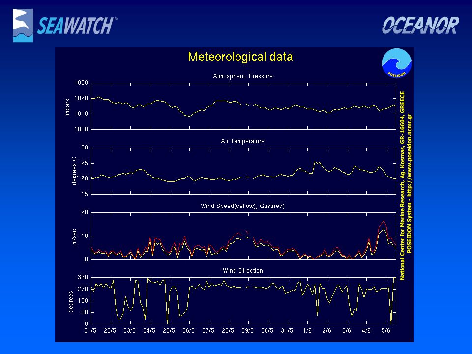
The Sea-Watch measuring station

7
POSEIDON Network

8
ADCP and CTD data from VOS The system consists of a satellite unit of communication via Inmarsat-C and PC’ s.The PC’s communicate with the ADCP and CTD units. The system will be enabled to receive and process information and transmit it in real time to the Operational Center.

9
Applications of the System Safety of life and transports at sea, prompt response in marine accidents, tourism development, fishing and sea-farming, coastal zone management, harbor and coastal works design and support of the greek scientific and research community.

10
Data from Crete

11
Clorofyl-a,, oxygen Data from Crete

13
Crete wave parameters

14
Santorini- current

15
Santorini- t/s profile

16
Weather Forecasting Products 4Wind 4Air temperature 4Relative Humidity 4Precipitation 4cloud cover 4Atmospheric Pressure 4Fog 4Snow 4Dust transport

18
Offshore Wave Forecasting 4Development: University of Thessaloniki, Department of Hydraulics and Environmental Engineering Resolution : 5kmResolution : 5km Coupling with atmospheric and hydrodynamic modelsCoupling with atmospheric and hydrodynamic models Data assimilation schemeData assimilation scheme Products : Height, Direction and Period fields

20
Hydrodynamic Model 4Development : University of Athens, Oceanographic modelling group Resolution : 5 kmResolution : 5 km Assimilation of AVHRR SST fieldsAssimilation of AVHRR SST fields Coupling with atmospheric and wave modelCoupling with atmospheric and wave model Products: 3-D Velocity, Temperature and Salinity fields

22
Pollutant Transport Model 4Development: University of Thessaloniki, Department of Hydraulics and Environmental Engineering Resolution : 5kmResolution : 5km Coupling with wave and hydrodynamic modelsCoupling with wave and hydrodynamic models Simulation of transport and chemical transformationsSimulation of transport and chemical transformations Products : Concentration of pollutant, beaching, evaporation etc.

24
Near-shore wave model 4Development: Technical University of Athens, Department of Naval and Environmental Engineering Resolution :100mResolution :100m Coupling with offshore wave, atmospheric and hydrodynamic modelsCoupling with offshore wave, atmospheric and hydrodynamic models Data assimilation schemeData assimilation scheme Products: Height, Period, Direction of waves plus bottom velocity and pressure

25
Examples of output from this system, which among others show that forecasts (line) may differ from observations (squares).
 may differ from observations (squares).")
27
THE COMPUTER SYSTEM AT THE SHIP DECK The prototype system at “Blue Star Ithaki”. In the later versions of the system the computer boards and the other electronics are within a box with fixed specifications and the control of the system is made through a touch- screen and track-ball system.

28
The installation of the stations The meteorological and navigation sensors are installed at a mast on the upper board of the ship. The entire installation is with specifications for marine environment.

29
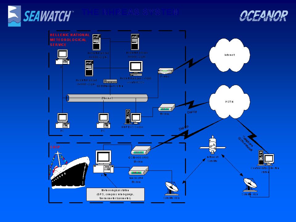
SHIP TERMINAL STATION The terminal station at the ships consist of two basic operational parts: The sensors for the meteorological and positioning data. The computer that supports: Two-way communications with the main server at HNMS. Gathering, retrieval and storage of the meteorological data and the position of the ship. Retrieval of weather and wave forecasted fields. Performance of ship stability calculations for safer and optimum navigation according to wave conditions, cruising speed and route to follow. Ν H R Ε Α S

31
. Fosen Traffikklag: Our goal is to arrange for a transport which gives maximum SAFETY, RELIABILITY and COMFORT.

32
Dangerous Areas Last February Fosen Trafikklag experienced an accident Where a window on one of our high speed vessels were broken from an unexpected wave in one of the areas identifyed as a ”dangerous” area.

33
Then maybe in a short time our high speed vessels can get this kind of information underway, supporting the decissions to be taken, ensuring SAFETY, RELIABILITY and COMFORT

Liknende presentasjoner


 SGO1910 & SGO4930 Vår 2004 Foreleser: Karen O’Brien Seminarleder: Gunnar Berglund>")

>")
 October 2009.>")


